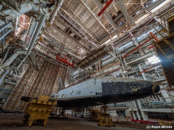
The abandoned hangar is located at the Baikonur Cosmodrome in Kazakhstan. The Cosmodrome is miles away and still in operation today. Because the NASA Space Program was recently shut down, this is the only area that astronauts can make their way up to the International Space Station via Russian Soyuz space.
The hangar was erected in 1974 for the Buran Space Shuttle Program where technology and design would fuse to create some of the most incredible exploration vessels ever conceived. The Buran Shuttle Program was halted in 1988 but the hangar was operational until 1993 and was the home to three of the most advanced pieces of technology of their time.
The collapse of the Soviet Union caused the demise of this facility in 1993. Sadly, only one shuttle of three ever partook in a mission. The shuttle completed one unmanned orbit before it was grounded and destroyed in a different hangar that collapsed on top of it.
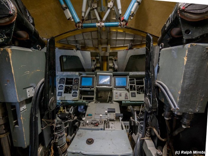
There are two shuttles from the Buran Space Program left and they sit in idle, turning into historic relics, within a forgotten and abandoned building located in Kazakhstan.
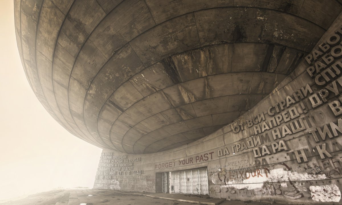
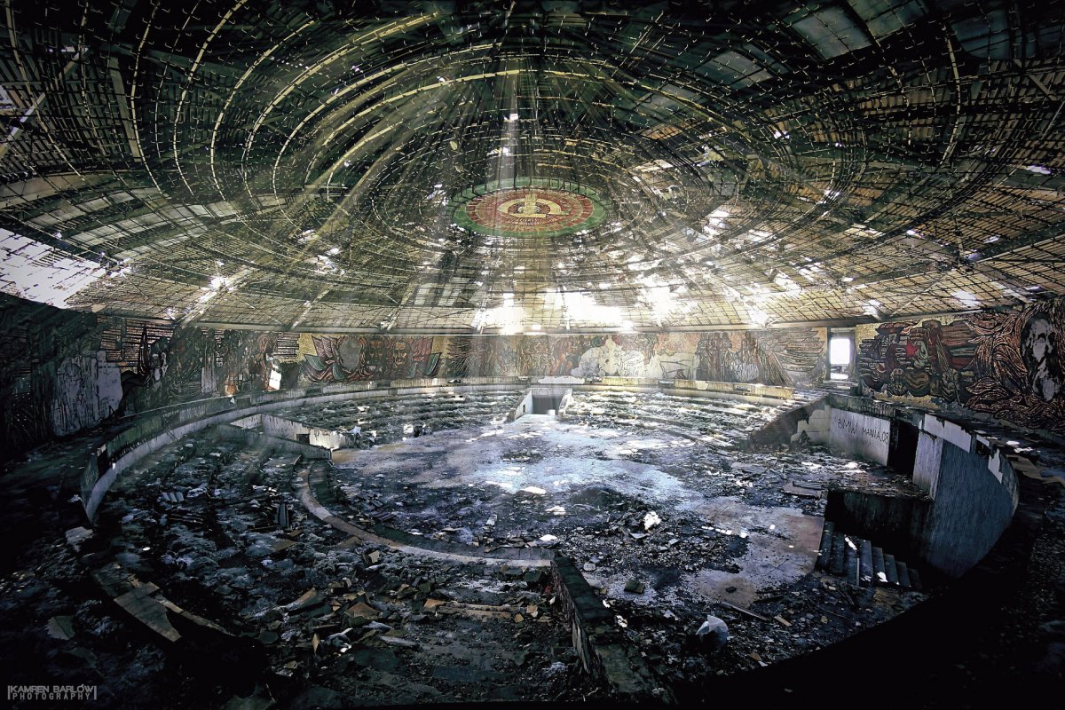
This monument located on Mount Buzludzha is the biggest ideological building in Bulgaria. It was built as a tribute to the creation of the Bulgarian socialist movement in 1891. Several access roads were built (today in a really bad shape) from Shipka and from the main road Stara Zagora – Roussée. The road exit for Buzludzha is a gigantic statue of Dimitar Blagoev).
The construction of Buzludzha was made possible thanks to government funds and supporters’ donations for an amount of around 14 186 000 leva (around 7 000 000 €). The site was built by civil engineering troops from the Bulgarian army and volunteers. The master builder was General Delcho Delchev who was in charge of the Stara Zagora civil engineering section. The author of this project was the architect Guéorguy Stoilov. Several famous painters and sculptors have participated to the decoration.
One of the wonderful roman villas reveals more on ancient life.
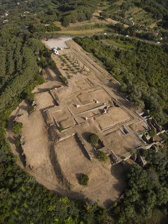
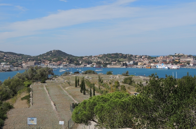
The Roman Villa delle Grotte is situated in the Gulf of Portoferraio, on Elba Island – Livorno, and it dates back to the 1st century BC.
The Villa was built in “opus reticulatum” and it also had an ornamental pool, stretching towards the sea with a heating and a cycling sistem.
The central nucleus of the villa was built along a central axis composed by the pool, which was probably surrounded by a garden. A small granite pier was found in the promontory cove and archaeologists thought it might have worked as a berth for docking boats and ships, in order to get to the Villa.
The Villa was partially destroyed to make room for artillery batteries during the conflicts between France and the Kingdom of Naples from 1799 to 1801.
(www.tuscanypass.com)
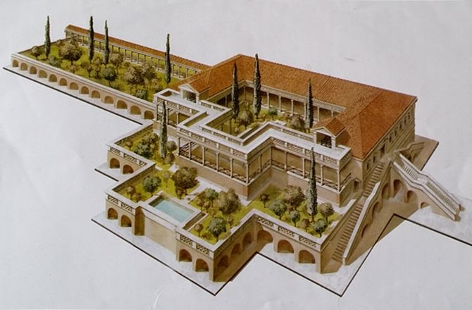
Le Grotte stretched toward the sea with gardens, porticoes, stairways and terraces with stunning bay views. A swimming pool encircled by a colonnaded porch, thermal baths, and rooms lavishly decorated with frescoes, marbles and statues made the site a luxury holiday residence.
Overlooking Portoferraio’s bay, the once magnificent 1st-century B.C. estate, known as Villa Le Grotte (the Caves) because of the shape of its vaulted facades facing the sea, has long been believed to have been owned by Marcus Valerius Messalla Corvinus.
According to archaeologists Laura Pagliantini, Luisa Zito and Luisa Quaglia, of the Archeo Color Association, the now ruined villa, which is currently closed to the public, has long been associated to Messalla’s patrician family but no evidence was ever found to confirm the speculation.
Startling evidence about Le Grotte’s owner came when archaeologists led by Franco Cambi, professor of methodology of archaeological research at the University of Siena, excavated the area just below the villa. Along with the remains of a large collapsed building, the archaeologists found five dolia — large earthenware vases — complete with their covers. Each vase could hold between 1,300 and 1,500 liters of wine. The vases were stamped with the Latin inscription “Hermia Va(leri) (M)arci s(ervus) fecit,” meaning “Made by Hermias, slave of Marcus Valerius.”
The archaeologists dated the farm to the 1st century B.C. The estate met its demise at the end of the 1st century A.D., when a fire destroyed everything. Fortunately the fire preserved materials made in raw clay, basically cooking them. The dramatic fire is likely the reason why the Roman villa was also abandoned at the end of the 1st century A.D., its most precious furnishing taken away.
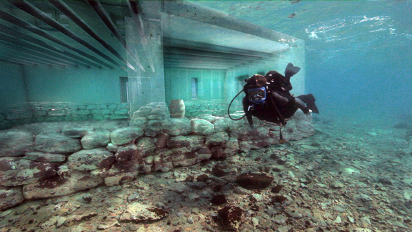
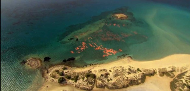
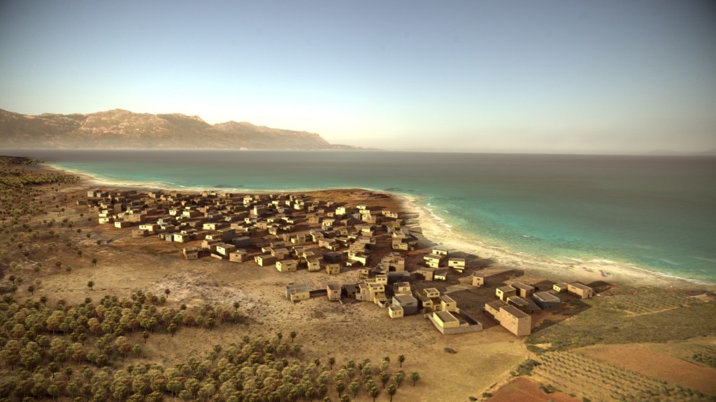
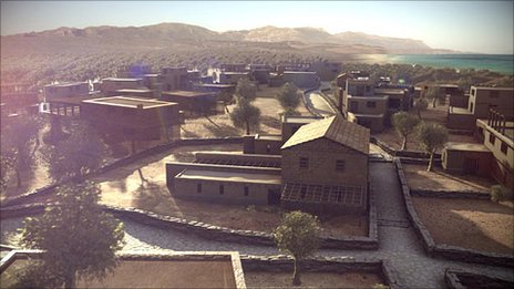
The city of Pavlopetri (Greek: Παυλοπέτρι), underwater off the coast of southern Laconia in Peloponnese, Greece, is about 5,000 years old, and is the oldest submerged archeological town site. The name Pavlopetri (“Paul’s and Peter’s”, or “Paul’s stone”) is the modern name for the islet and beach; the ancient name or names are unknown.
Discovered in 1967 by Nicholas Flemming and mapped in 1968 by a team of archaeologists from Cambridge, Pavlopetri is located between the Pavlopetri islet across the Elafonisos village and the Pounta coast. The coast, the archeological site as well as the islet and the surrounding sea area are within the region of the Elafonisos Municipality, the old “Onou Gnathos” peninsula (according to Pausanias). It is unique in having an almost complete town plan, including streets, buildings, and tombs.
Originally, the ruins were dated to the Mycenaean period, 1600–1100 BC but later studies showed an older occupation date starting no later than 2800 BC, so it also includes early Bronze Age middle Minoan and transitional material. It is now believed that the town was submerged around 1000 BC by the first of three earthquakes that the area suffered. The area never re-emerged, so it was neither built-over nor disrupted by agriculture. Although eroded over the centuries, the town layout is as it was thousands of years ago. The site is under threat of damage by boats dragging anchors, as well as by tourists and souvenir hunters.
The submerged architectural remains continue southwards to the islet of Pavlopetri, on top of which the remains of walls and archaeological artefacts are still visible. Also found among the ruins were stone-lined graves, probably from the Meso-Helladic period and in adherence with the practice at the time of burying infants and small children within the settlement. At the edge of the town under two small reefs are two Mycenaean chamber tombs. On the beach at Pouda is an extensive prehistoric cemetery of cist graves dating from the 3rd and 2nd millenia BC. Of particular interest are the ceramic vessels known as pithoi found at the site, in which the prehistoric inhabitants of Pavlopetri stored their wheat, oil and other products such as figs and olives, fish and meat. Other pots found there indicate they had developed close links with Kythera, Crete, the Cyclades and the north-eastern Aegean. Tools made of obsidian from the island of Milos indicate that the prehistoric population of what is now part of Vatika was in contact with the people of the Cyclades since 2,800 BC.
The town reached its peak in the early Mycenaean period (15th century BC). The Mycenaeans would have used the pithoi and other storage vessels found there in order to store the goods they either produced themselves or traded with others. Also found at the site are cups for drinking wine, small vessels decorated with flower patterns for storing aromatic oils, and even sieves, probably used for preparing some kind of beverage. The discovery of a large number of weights used in weaving looms show that the women and children produced textiles and valuable clothing, activities known from Linear B tablets found at Mycenaean palaces at Pylos and Knossos. Garments were dyed with porphyry which was produced in the area as well as on the neighbouring island of Kythera (ancient Porphyroussa).
The people of Pavlopetri were farmers, livestock breeders and fishermen; they produced textiles and processed porphyry for dyes. They traded as early as the Proto-Helladic period (3000 BC).
The settlement appears to have been abandoned in about 1100 BC. The latest archaeological evidence indicates that it was populated once more in the Classical and Hellenistic periods. Roman and Byzantine pottery found there may indicate that the local population was engaged in quarrying and processing porphyry, on which a special tax had been imposed by Emperor Septimus Severus. Under Roman rule, the Strongyli lagoon (now a Natura 2000 wetland) was used by the inhabitants of ancient Vies for producing salt, then a valuable commodity.
Pavlopetri occupied a prominent prehistoric place in the southern part of the Maleas promontory and was one of, if not the most important ports in the southern Peloponnese as it monitored shipping from the ports of southern Laconia to the Aegean and the western Mediterranean. The narrow channel between Elafonisos and Kythera was one of the most important shipping lanes in the Mediterranean, enabling communication between East and West.
The city of Pavlopetri is part of the underwater cultural heritage as defined by the UNESCO in the UNESCO Convention on the Protection of the Underwater Cultural Heritage. All traces of human existence underwater which are one hundred years old or more are protected by the UNESCO Convention on the Protection of the Underwater Cultural Heritage. This convention aims at preventing the destruction or loss of historic and cultural information and looting. It helps states parties to protect their underwater cultural heritage with an international legal framework.
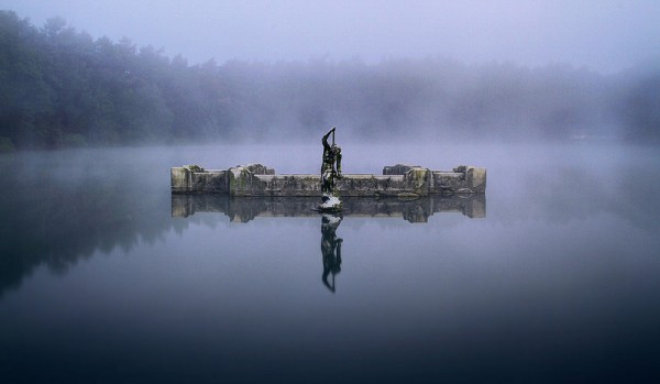
Deep in Surrey, near Godalming, lies the village of Witley. A mile and a quarter west, in a ramshackle wood, next to a walled kitchen garden, you’ll find a holly tree wrapped around a hut with a door in it.
Go down the spiral concrete steps, and there, 40ft beneath the surface, lies a teardrop-shaped tunnel that leads to Britain’s most extraordinary folly — a ballroom, built of iron and glass, beneath a lake.
Leading off it, an aquarium-cum-smoking room was added, where guests puffed on their cigars and admired the passing carp.
Above the domed, glazed ceiling of the underwater ballroom, a yellowish natural light shines through the murky lake water. A giant statue of Neptune stands at the dome’s peak, poking above the surface, apparently walking on water.
This underwater ballroom is the last, mad, magnificent fragment of a Victorian fantasy world. To create it, 600 workmen dug out four lakes, swept aside hills that got in the way of the view, and built a 32-room neo-Tudor house which was packed with treasures from across the world, including Italian statues and a bronze dolphin’s head so big that it got stuck under a bridge on the way from Southampton. (They had to lower the road to get it out.)
Most of this architectural fantasia has gone now. The house, gutted by fire in 1952, was later demolished. A few forlorn lodges and some stables survive. No one dances in the underwater ballroom any more.
Kaleto is one of the most preserved fortresses in Bulgaria. In the 1st – 3rd century, the Romans kept a fortress here to guard the strategic paths, which were crossing the area, using the advantage of the rock’s natural ability of hindering accessibility. Located on the north slopes of the Balkan Mountains, the fortress was used in ancient times, first by the Roman’s as part of their defensive blockade and subsequently by the Byzantine Empire. The fortress was extended by the Bulgarians. Its significance grew after the separation of Vidin’s Kingdom, including the territories of today’s North-West Bulgaria, parts of East Serbia and South-East Romania. The fortress, named Belgrad at that time, was one of the last fortresses to be taken over by the Turks at the end of the 14th century. They placed a garrison here, which played a key part in the defense of the country’s West areas and crushed the Bulgarians’ revolts. In the period since 1805 till 1837, the Kaleto Fortress was extended and reconstructed to allow the use of fire guns under the supervision of French and Italian engineers. The memorial plaques after the construction are written both in Bulgarian and Turkish – the unique case in the history of Turkish fortresses’ constructions. The extension included 3 courts (all of them with the capability of defending independently) located in a total area of 10 211 sq. meters, and one separate fortification. There are two main gates – Vidin Kapia and Nish Kapia. The fortification’s walls, which are 10 meters high, were added with gun embrasures. For the cannons, 3 bastions were built, each allowing the use of 15-16 cannons. In wartime, the number of the fortress’ defenders and the surrounding hills reached up to 3000 people. Part of Bulgarian Tourist Union’s “100 National Tourist Sites”: Belogradchik Rocks and Fortress. Working Hours: Everyday, Summer: 9am – 6pm; Winter: 9am – 5pm Stamp from BTU is available.
Belogradchik rocks extend around 30 km length, 3 – 5 km width and up to 200 m height. The most magnificent rocks are surrounding Belogradchik : Madonna, The Rider, The Monks, The Student, The Lion, The Bear, Adam and Eva, The Casle. Four kilometres from the town, around Lepenitsa cave, there is another great group of rocks, where the biggest one i called The Dinosaur. Near by village Borovitsa are The Pinestone and The Beestone. From the platform of the famous Stone of Thought you can see an endless view of peaks, rocks, precipices, lush meadows, cool streams and the calm lineaments of Old mountain. Upon this view man becomes wordless. The name of each rock formation is given by the folklore. The flora surrounding Belogradchik rocks includes many rare species typical for the Balkans and written in the Red book of Bulgaria. The animals are represented by imperial eagle, owl, small vulture, black stork, wolf, wild boar, royal slag, deer, dormouse and etc. You can take one of the rambling paths from Belogradchik to the rocks, suitable also for cycling.
Every stone here has a history and a legend full of suffering and heroism to explain the incredible stone beauty. Centuries ago between the rocks there was a nunnery. Early every morning the nuns went out to pray to God. The youngest among them – Vitinia couldn’t hide under the cassock her unbelievable beauty. The rumour about her beauty spread all over the Roman empire. One day on the Day of Peter when the monastery could be visited Vita met with the roman Antonio. They hided their love from the nuns long time but after an year the fruit of their love saw the light of the day. Child voice filled the monastery with crying. Vita was revealed and faced the strict law of the nuns. They decided to curse her and expel her from the monastery with her child. At that moment from the hill came Antonio riding his white horse. He started begging the nuns not to punish his beloved. Then happened a miracle. Suddenly a storm started, a thunder stroke and the earth shook. The monastery laid in ruins and everything turned in stone – The Monks, The Rider, even Vitinia who turned in Madonna caring her child.
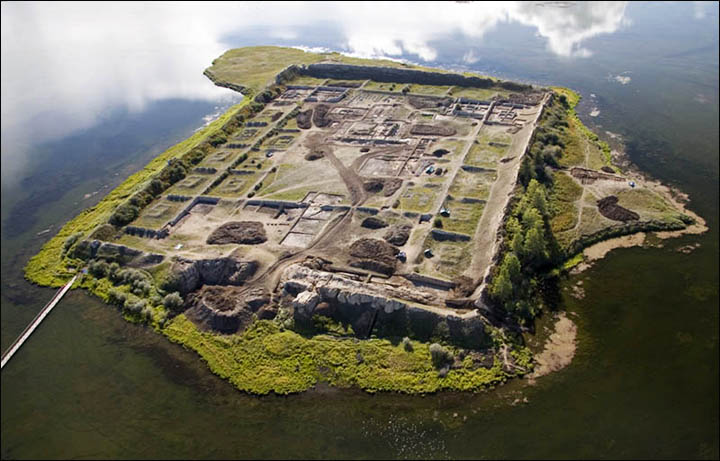
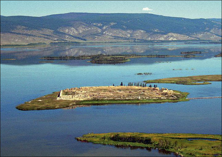
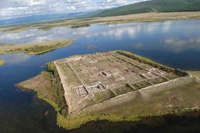
Por-Bazhyng (Russian: Пор-Бажың) is the name of a ruined structure attributed to the Uyghur Khaganate. It is located on an island in the middle of Tere-Khol, a lake in Tuva. The name Por-Bazhyng translates from the Tuvan language as “earthenware house”.
Most likely constructed in 757 AD, the complex has fascinated and frustrated experts in equal measure since it was located in the middle Tere-Khol, a high-altitude lake in Tuva, in the late 19th century.
First explored in 1891, with small-scale excavation work later carried out between 1957 and 1963, it was not until 2007 that proper research took place at the site.
Archaeologists found clay tablets of human feet, faded coloured drawings on the plaster of the walls, giant gates and fragments of burnt wood. But nothing yet has provided a definitive answer as to why the structure was built, and excavation work continues.
Identification of the structure’s purpose is obscured because of the scant amount of evidence of daily human activity at the site. The theories include a fortress, a palace, a monastery, and an astronomical observatory.
While debate continues about the use of Por-Bajin, there is growing evidence it was a community or palace complex centred around a Buddhist monastery. Certainly, there is an argument that its layout is typical of the palaces of the Buddhist Paradises as depicted in T’ang paintings.
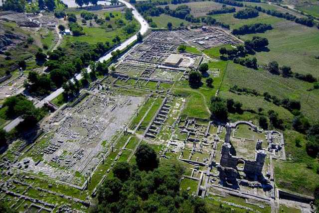
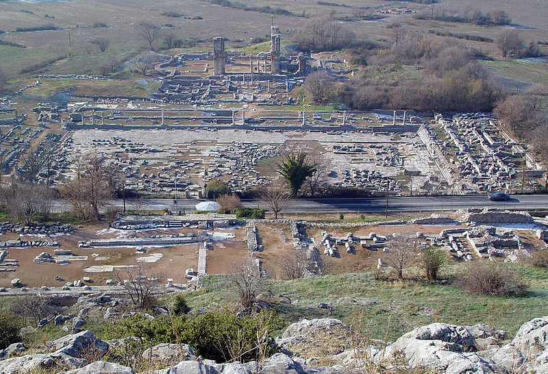
The area of Philippi hosts a series of archaeological monuments, witnesses to a long historical path during which civilisations intersected and developed. The first archaeological evidence of organised life in the area dates from prehistoric times (5500 BC) and is found in the tell of Philippi, Dikili Tash. This is the oldest Neolithic settlement in the whole of East Macedonia and Thrace, and one of the largest tells in the Balkans. Life in the ancient city of Philippi began when the Thasians founded the colony of Krenides in the interior in 360 BC. The colony was soon (356 BC) conquered by Philip II of Macedon (359-336 BC), fortified and renamed Philippi. The Battle of Philippi took place in 42 BC, between the armies of the Republicans Cassius and Brutus, and the supporters of Julius Caesar, Octavian and Mark Antony. The Emperor accorded Philippi the honour of implementing Roman Law and the name Colonia Augusta Julia Philippensis in 27 BC.
The Via Egnatia, one of the longest military and trading roads in the ancient world, also passed through Philippi, bringing the city to the forefront of major historical events.
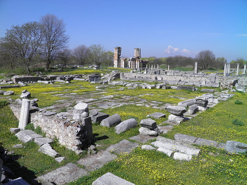
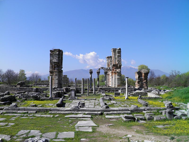
Philippi played a decisive role in the expansion of Christianity when, in 49/50 AD, Paul the Apostle visited the city, founded the first Christian church in Europe and baptised the first European Christians, an event that affected the whole continent. The Epistle to the Philippians, the first Christian community in Europe, sealed the long and close relationship between the Apostle and the Philippi congregation. There was an episcopal see of Philippi from as early as the mid-4th century AD. The exceptional examples of early Christian architecture (the three Early Christian basilicas, the Octagon church, baths that remained in use into the Christian period, the “Bishop’s Palace”, private houses), dating from the mid-4th century AD onwards, bear eloquent witness to the power and vitality of the Church of Philippi and its influence on the contemporary Christian world. These were closely linked to developments in the metropolitan see of Constantinople, if not directly financed by it.
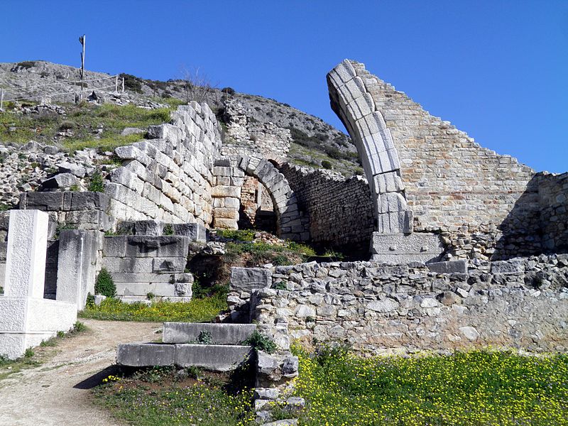
The ruins of Direkler (Basilica B), drawn by H. Daumet in 1861.
The city was abandoned at an unknown date, but when the French traveller Pierre Belon visited it in the 16th century, there were nothing but ruins, used by the Turks as a quarry. The name of the city was preserved at first by a Turkish village on the nearby plain, Philibedjik (Filibecik, “Little Filibe” in Turkish), which has since disappeared and then by a Greek village in the mountains.
Noted or briefly described by 16th century travellers, the first archaeological description of the city was made in 1856 by Perrot, then in 1861 by Léon Heuzey and Henri Daumet in their famous Mission archéologique de Macédoine.[1] Nevertheless the first excavations did not begin until the summer of 1914, and were soon interrupted by the First World War. The excavations, carried out by the École française d’Athènes, were renewed in 1920 and continued until 1937. During this time the Greek theatre, the forum, Basilicas A and B, the baths and the walls were excavated. After the Second World War, Greek archaeologists returned to the site. From 1958 to 1978, the Société Archéologique, then the Service archéologique and the University of Thessalonica uncovered the bishop’s quarter and the octagonal church, large private residences, a new basilica near the Museum and two others in the necropolis to the east of the city.
(www.en.wikipedia.org/wiki/Philippi, Hellenic Republic Ministry of Culture)